Fox Creek Park Wetland Delineation Report
Prepared By:
Mountains-to-Sea Ecological
828.551.8225
PO Box 255
Barnardsville NC 28709
Sept-OCT 2022

INTRODUCTION
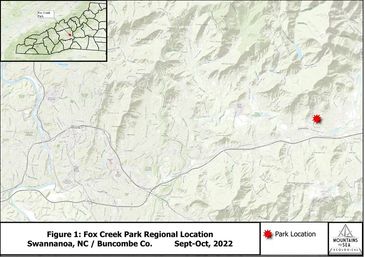
At the request of the Allen Dye of the Swannanoa Community Council, Inc. (“SCC”), MTS Ecological delineated wetlands of the 2.35-acre “Fox Creek Park” property in the Grovemont community in Swannanoa, NC (Figure 1, p2). The delineation was performed to demarcate wetlands 1) to property location future trail or bridge construction activ
At the request of the Allen Dye of the Swannanoa Community Council, Inc. (“SCC”), MTS Ecological delineated wetlands of the 2.35-acre “Fox Creek Park” property in the Grovemont community in Swannanoa, NC (Figure 1, p2). The delineation was performed to demarcate wetlands 1) to property location future trail or bridge construction activities; 2) avoid and minimize wetland impacts, and 3) aid in potential future wetland and stream restoration efforts per requirements by the US Army Corps of Engineers (USACE).
The site is in central Grovement between W. Charleston and Hawthorn Avenues, Summer Street, and Ivanhoe Drive and is bounded by small private tracts on all sides. It sits in the central upper region of a tributary referred by residents locally as “Fox Creek.” Fox Creek headwaters originate 0.3-0.4 miles north of the park at the toe slopes of Four Brothers Knobs (mountain). Fox Creek drains south/southwest from the park into the Swannanoa River after passing through industrial / commercial zones near Hwy 70 and I-40, where Fox Creek is ditched and not apparent. In the early 1900’s, E.W. Grove owned the property and developed” a small pond which was drained or abandoned in the 1960’s. A small portion of this former pond is currently a wetland, and one primary stream channel with two small tributaries occurs onsite.
METHODOLOGY
Delineations were performed on October 1 and 25, 2022 by Kevin Caldwell and Bob Gale. Delineation timing was based on rainfall to observe the highest water table possible. Prior to delineation, relevant information and data for the site was reviewed including previous reports, National Wetland Inventory (NWI), the 2022 Natural Heritage Program (NCNHP) “Element Occurrence” database, USDA Natural Resources Conservation Service (NRCS) soils data, and other relevant GIS data. Field methodology followed the United States Army Corp of Engineers (USACE) 1987 manual served as the delineation basis with using the USACE 2012 Regional Supplement and the 2020 National Wetland Plant List (NWPL).
Site review for wetlands occurred within obvious wetlands and upland zones, with soil samples collected to document wetland or upland status. Streams internal and external to wetlands were mapped at their centerlines using handheld GPS and aerial imagery.
Note that the wetland vegetation inventory occurred within a single plot and is not comprehensive to the entire wetland due to time of year. Spring 2023 vegetation inventories will focus on location of additional (and upland) species composition for future educational and restoration purposes onsite.
Soils were sampled by Bob Gale using a post-hole digger in two locations, reviewing hydric soil characteristics and presence of water within twenty inches. Soils were documented using the Munsell Soil Chart for wetland and upland soil Identification.
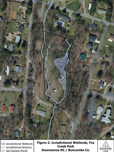
Data collection sheets from the 2012 Regional Supplement and the 2016 Regional Hydric Plants List were used to document wetland (W1) and upland (U2) plots as depicted in Figure 2 (p.4). Data and mapping for wetlands, streams, and soil-sample locations were collected using handheld GPS and processed in Quantum GIS (QGIS). Acreage and linear footage calculations were processed in QGIS.

SUMMARY OF FINDINGS
SUMMARY OF FINDINGS
One area-based jurisdictional wetland and two jurisdictional streams occur within the property (Figure 2). The wetland comprises ~0.39 acres (~16% of property acreage). Four stream sections comprising ~415 linear feet occur onsite. Only “normal” wetland conditions exist onsite and no difficult wetland situations exist.
Wetlands are fores
One area-based jurisdictional wetland and two jurisdictional streams occur within the property (Figure 2). The wetland comprises ~0.39 acres (~16% of property acreage). Four stream sections comprising ~415 linear feet occur onsite. Only “normal” wetland conditions exist onsite and no difficult wetland situations exist.
Wetlands are forested and dominated by native wetland Obligate (OBL) and Facultative Wetland (FACW) plants. The wetland zone is naturally occurring and is dominated by native plants, and hydric soils, and it may be relict and bordering or consisting of historical pond shallows after impoundment.
Streams are described as follows:
1) Primary tributary (~190 linear ft); defines the western park boundary.
2) Springhouse tributary (~40 linear ft); contains a former headwater spring or seepage that was modified into a springhouse historically, and which intersections the primary channel in the northwestern region.
3) Secondary tributary (~164 linear ft); defines the eastern boundary and bounds the eastern wetland edge, with headwaters in the northeastern park corner. It intersects the primary stream channel at the dam and southern boundary.
4) Northeastern tributary (~30 linear feet); intersects the secondary tributary from the northern boundary where its headwaters are covered by fill on the adjacent private lot.
The former lake-bed is filled with sediment from a combination of stream sedimentation and colluvium, flooding, and/or fill material placement following pond abandonment and thus wetland conditions do not exist in this park region.
No federal Threatened and Endangered (T&E) species were observed.
WETLAND & UPLAND COMMUNITY DESCRIPTIONS
Typical area-based small wetlands comprise the central-eastern region, while impaired streams comprise most of the eastern and western property boundaries as low gradient, small-cobble, small streams draining north to south. Boggy, hydric soil conditions comprise much of the forested wetland along the stream interface. Sphagnum moss, indicative of true bog conditions was not observed. Streams onsite are typical of developed, residential areas in the region.